


A gallery of satellite images taken – not vertically – but at an angle, published by Planet Labs.
To wit:
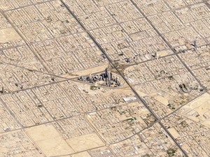
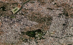
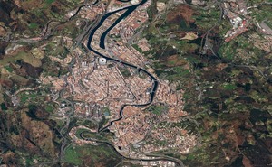
…the satellite imagery we’re most familiar with — taken straight down — flattens and obscures the visual cues we get from perspective, making the imagery appear like maps, not photos… from an angle, the view becomes altogether different: the mountains rise to their commanding height, valleys regain their depth, and background features recede into the distance. It’s like getting a view out the window of an airplane 450 kilometers high.
From top: Monte Fitz Roy in Patagonia; Riyadh, Saudi Arabia; Sao Paulo, Brazil; Klyuchevskaya volcano in Russia and Bilbao in Spain.
Sponsored Link


Riyadh laughs at Dublins urban sprawl.
That’s a lot of people chortling. Riyadh has over 6.5 million inhabitants.
saudis don’t really laugh much
Do you find a lot of people don’t laugh much when you’re around, snookums?
yes
most gaze in muted wonder
Muted wonder. That’s what it is, I’m sure.
Awwwwwwww.
that was unkind
Pffffffffffffft.
very nice
but i think you’ve got Sao Paulo and Bilbao mixed up
oh you rascal, Chompsky.
Thanks for the heads up BB!
Chompsky
Looks like Sim City
I love that game
I had to hide it so I could do something productive
and now I have wasted hours trying to find it
I swam in that lower lake on Fitzroy on a beautiful summers day many years ago. It was magnificent
Riyadh looks as much of a poohole as you’d expect.