

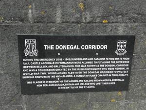
From top: Flying boat Sunderland over Lough Erne in the ‘Donegal Corridor’ during the ‘Emergency’
Or pride?
You decide.
This Day In Irish History tweetz:
This day 79 years ago – 21 February 1941 – the first flight took place over the ‘Donegal Corridor,’ a strip of land in the Irish state used by Royal Air Force planes during the Second World War. Though Ireland was officially neutral, the airspace was secretly allowed to be used.
Aerial dogfight!
Sponsored Link

…now known as the Shannon corridor…
On Clare Island of Mayo there’s a grave to members of the Canadian Airforce who died when their flying boat crashed off the island during the war. Not sure if they were lost or if the above corridor was not only in Donegal.
That the 26 Counties was Neutral during the WW!! was pure fiction, they fed England
its people and its army, they supplied labour, intelligence, had meetings between
the Irish Army and the British Army at the highest level, they even supplied the keys
to cypher codes that the British were unable to crack in Bletchley, perhaps now in the
light of later times that it should be recorded that Eammon DevValera was one of the
duplicitous politician to hold power and abuse it, add to this his involvement in a Civil
War that never should have been
Didn’t a west Mayo weather station influence timing of D-Day.
Indeed.
https://www.rte.ie/culture/2019/0529/1052425-how-an-irish-weather-forecast-played-a-critical-role-on-d-day/
Theres a plaque at the top of the rougey rocks looking out onto tullan strand in bundoran, dedicated to an aircrew who tried to make an emergency landing.
One day i spotted part of the landing gear sticking out of the sand at the bottom of the cliff, its still there and visible from time to time.