

Version 1: ’24 hour vehicular deliveries and access from Dame Street: between South Great Georges Street and Anglesea Street area. Concept aerial view of space in use, looking west over College Green and Dame Street.’
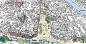
Version 2: ‘Vehicular deliveries and access from Dame Street: between South Great George’s Street and Anglesea Street area from 6am to 11am, and traffic-free after 11am. Concept aerial view of space in use, looking west over College Green and Dame Street.’

UPDATE: versions 1 and 2 compared.
This afternoon
Further to Dublin City Council’s launch of a public consultation on updated proposals to pedestrianise College Green and much of Dame Street, Dublin 2…
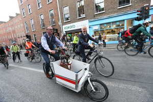
…Dublin Cycling Campaign tweetz:
There are two versions (above) of the proposal: One which allows 24hr access to Dame Street for deliveries etc, and the other which would restrict vehicular access on Dame Street to 6am-11am. A two-way segregated cycle route along Dame Street is provided in both options.
Both proposals include the pedestrianisation of much of Dame Street from College Green as far as South Great George’s Street.
The proposal is strikingly ambitious, but that is exactly what’s required considering the social, economic, health & environmental challenges we face. What do you think?
FIGHT!


Chris The Sheep style photographs?
Either would be a giant leap forward, Lived in Utrecht and most of the city is pedestrianised, yet its thronged and lively with plenty of space for wheelchair users and access for deliveries.
I think these are really cool drawings and I would like a giant copy of them. The level of detail!
was looking at this a while ago and trying to figure it out
not entirely sure but seems to me that pedestrianusing only as far as the junction with George’s St would turn the other end of Dame St and Lord Edward St into a traffic congestion nightmare. and even more so would destroy Parliament Street, which is one of the nicest streets in the city. from Capel St, crossing Grattan Bridge and onto Parliament St towards City Hall is one of my favourite stretches in Dublin.
would be nice to see where the proposed current traffic routes through this part are to be directed, we all want a nice big civic area and that spot by the wax museum is a travesty the way its lost to the taxi rank, but honestly this is a significant throughfare for I’d love to know how this would effect the other routes for commuters, workers, services, visitors and the rest