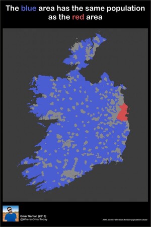
Omar Sarhan writes:
Here’s a little map I created, nothing special just a little exploration of population figures. Fight!
UPDATE:

Sponsored Link

Omar Sarhan writes:
Here’s a little map I created, nothing special just a little exploration of population figures. Fight!
UPDATE:
Wow, the population density eases up right along the Dublin county line. How convenient.
;)
It actually does.
My mam expressly moved to Celbridge because she lived through Tallaght going from a village to a mega-estate in like 10 years. Wanted to get somewhere Dublin planners couldn’t touch ;o)
Celbridge is just about the only north Kildare town to have escaped turning into a mega estate… for now. dun dun dun
Are the wallabies on Lambay included?
Data on wallabies is too inaccurate to be usable!
And we wonder why we have a house price/transport/homelessness problem.
What does that even mean?
It is an interesting graphic but it excludes every medium sized Irish city or town (Cork, Limerick, Galway, Wexford, Tralee…).
By no means do we have a problem that our population is too concentrated in large towns. We need more agglomeration, not less. Get over this silly fear of cities.
We’re very similar to New Zealand in this regard with its analogous population. Well over one third of the Kiwi population live north of the city of Hamilton (which is basically a suburb of Auckland, the largest city). While a preponderance of all that is great and good (and not so good) concentrated in one small area of the state is not recommended nor is widespread dispersal. Focused regional agglomerations to balance the area around Dublin are they best way forward for the provision of services, utilities, hospitals, education etc…
Ye sure this is right?
It’s not right. 50% of the population is not in Dublin.
It probably is right though. The Dublin hinterland and major population centres in the rest of the country aren’t in blue.
Bingo!
And yes i know it does not represent all of Ireland outside Dublin but its close.
Except for almost every single town
It is correct, I can mail you the data if you like. send me a DM or email and I’ll forward it on.
Dublin city alone has a population of 550 thousand, and 1.5 million in Dublin county, and that’s not even counting Meath, Kildare, Wicklow etc. … https://en.wikipedia.org/wiki/Greater_Dublin_Area
That’s out of a national population of 4.6 million.
Another quick search and I find that Dublin is 922 square km; Republic of Ireland is 70,273
Rounding to 1000 and 70,000 respectively – If you were to draw a grid of 7 x 10 then Dublin would occupy a single square. Each of the remaining 69 squares would have to have roughly 45k people each to make up the remaining population, each of which is less than 1% of the population of Dublin.
Where’s the Shannon gone?
Didn’t you hear? Irish Water drained it to feed Dublin.
Heh :)
Denis O’Brien used it to wash his big bottom
It survived, but was moderated… I can live with that :)
I’m glad it was moderated. “big bottom” has a nice ring to it.
Or did they change [REDACTED] to the lord and overseer’s official birth-name?
Never understand the us and them, country v Dublin stand off. As a Dub (who now lives in the country) I can attest to the fact that 40/45% of our street when I was growing up (70s/80s) was populated by country people including my own parents. We, the offspring, are now Dubs but ‘True blue’ dubs are possibly/probably out numbered by country folk in the capital if the truth be told. Its silly to see it as an us and them argument at all given that Dublin’s population growth and economic success is by and large fuelled by country folk abandoning the country. Cue resource pressures and near constant escalating property prices which inevitably spills over into commuter belt counties as rural Ireland collapses. Its just a simple fact of modern life. More people now live in cities (worldwide) then ever.
“Leinster by the grace of affluence “
Agreed.
I am always baffled by the anti-urban sentiment in the country in general. We don’t seem to understand/accept the economic benefits of cities.
I don’t know anyone who has emigrated to a one-off home a couple of miles outside a sprawling village abroad. They are all going to larhge cities – NY, London, SF, Sydney, HK, Singapore, Berlin…
Reminds me of that week I had leprosy.
Nice work Omar.
So can we get DART Underground now??? Or do we still have distribute billions to rural backwaters every year?
+1!
Dublin needs a mayor with a budget who doesn’t have to faux sympathise with people living on boreens in Connemara wondering why they don’t get a Luas.
I have never seen it put this before, but you are dead-right: income transfers are all well and good, but the fact that the greater Dublin area can’t get a few billion euro for essential infrastructure is taking the mickey
The fact we still don’t have a rail link to the airport a disgrace.
+1
I agree with the above regards infrastructure – Dublin is a disgrace and needs an overhaul, but I think it’s really unfair to put the blame on people outside the city.
As a country-buck who now lives in the city I can say for certain that Dublin has a lot going for it. If you take a trek to west Mayo, north Kerry, Sligo or nearly all of Donegal you will see the striking difference: The roads in the city are by-and-large better. There are hospitals within driving distance. There are pedestrianised areas and well-maintained parks.
The infrastructure throughout the country is a shambles, but at least in Dublin there are places to work and ways to get to where you need to go: Try finding a bus going 20 minutes down the road in Cahersiveen. Dublin is well catered for as the country goes, even if it is nowhere near international standards. Our real issue is that our tax rate has been too low for years, for a small country with a dispersed population. Setting aside the grievous misuse of funds (voting machines, Irish Water etc.), we still don’t bring in nearly enough through taxation to put any proper infrastructure in place. That’s not a country/city issue, it’s a national one.
The more you make this argument the more you perpetuate the urban/rural divide, which plays nicely into the hands of our divide-and-conquer politics: “Keep them fighting against each other and they won’t take it out on us”.
Interesting map but not sure it’s that revealing about Ireland. You could probably create a similar map of any country if you exclude the main centres of population outside of the capital.
A similar depiction of Australia would be very interesting!
Sydney (21%), Melbourne (19%), Brisbane (10%) have 50% of the Aussie population. So you could do a similar map, with 3 small red spots and the rest of the country in blue.
https://en.wikipedia.org/wiki/List_of_cities_in_Australia_by_population
Good.
Once ye all get the hell out on christmas eve.
Screw you! Though I am going ‘home’ for Christmas for the first time in years.
Must start thinking about making the aul brandy, sorry I mean Christmas, cake. Mmmm.
Oh the weather outside is frightful LA LA LA!!
specially for you hoop…..
https://www.youtube.com/watch?v=btqSxlUJyxo
Thanks 3stella.
Tis well for yiz with yeer soda bread, busy oul wans and choice of one single formica-clad pub in which to spend a sad evening…..
Some serious flooding in the northeast. Unless you meant just to cover just the larger of the two states in the country.
What can I say, it was late, I was sleepy, and I didn’t have NI data handy.
The neighbouring UK province isn’t really relevant.
Couldn’t resist ;o)
But actually settlement patterns don’t really respect the border.
But wait what are the grey areas?
Omar,
I love maps, too. I think it would be more useful to remove the grey bits. Do the red for Dublin, then starting from the South go as far north as it would take to equal the population of Dublin, make that section blue. This would be a useful/realistic comparison. You could do a similar map, starting from Donegal, going south, until 50% of the population was in blue.
That’s a wonderful idea, i had the data handy so I did it from the south to north, it looks pretty awesome alright.
http://i.imgur.com/bHGUXgd.png
Hi Omar,
Great. That is interesting. Can you use the provinces, to compare their population with Dublin – how much of Munster would be blue, to equal Dublin’s population? It looks like it would be close to 100%.
I have just checked Wikipedia:
Co. Dublin: 1.271 million (2011)
Munster: 1.246 million
A map, using the counties, showing the highest number of counties (the ones with the lowest population densities) that would equate to Co. Dublin’s population, would be interesting. Irish people can relate to the counties, rather than random blue/grey areas on the map.
Have a look at this map. It divides Ireland into four based on poulation.
http://imgur.com/q439KW0
They syrian refugees can have the grey bits, esp that grey bit in the southwest …
The Southwest !! Haven’t they travelled far enough already to escape persecution? Then there’s the language barrier.
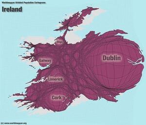
In a similar vein, here’s a map showing areas that have a population of zero:
https://planetgeogblog.files.wordpress.com/2014/05/empty-ireland.jpg