Gulp.
Met Éireann tweetz:
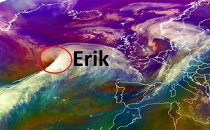
Here’s the latest infrared satellite image from 8am. Storm Erik is clearly visible just off the northwest coast. Gusts of up to 120km/h have been recorded this morning with the strongest winds in Galway, Mayo & Donegal.
Orange warning in effect as Erik brings 120km/h gusts (RTÉ)
Meanwhile..
The UKMO Analysis chart at 06:00 this morning shows #StormErik just off the West Coast with a center of 968 hPa, Satellite image for same time also shown along with satellite image at 07:30. Top gust so far is 120kmh at Mace Head. pic.twitter.com/bX0WmsD7z0
— Carlow Weather (@CarlowWeather) February 8, 2019
Yesterday: Incoming