
Anyone?
Lines MUST close at 2.30pm
Update:

Sibling of Daedalus writes:
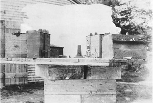
“It’s the scale model used by the Irish-American architect Augustus Saint-Gaudens (above) when designing the Parnell Monument, erected on this day in 1911. Sadly, the model itself was subsequently destroyed, and only this photo (top) remains.
Saint-Gaudens, born in Dublin in 1848, was the most famous American sculptor of his generation. He designed the statue of Parnell which stands at the base of the moment. The obelisk and base were the work of Henry Bacon (who also designed the Lincoln memorial) and GP Sheridan.“With An Fianna Eireann training in the Rotunda Gardens, Maud Gonne’s radical women’s organisation, ‘Daughters of Ireland’ up the way in North Great George’s Street, the monument was right at the heart of radical Dublin of 1911. No wonder that, according to RF Foster in his new book [Vivid Faces] , the network of small shops and restaurants around O’Connell Street and Parnell Square soon became thronged with young coffee sipping would-be revolutionaries…And on that subject congrats to Andy, Slightly Bemused and Ciaran Adamson for guessing correctly [see comments].”
FIGHT!
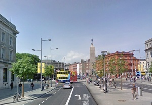
And that view today?
Saint-Gaudens Pic: Ansmagazine
Google Street View
Thanks Louis Le Fronde
an old photograph with some white-out on it.
That’s no white-out, Starina
I can see the Ambassador and the Parnell obelisk. So I’m guessing this might be the construction of the Carlisle Bridge (now O’Connell Bridge)?
or a scale model of it, by the looks of it
I agree. Looks like a diorama of the top end of O’Connell Street (perhaps when still Sackville Street), mounted on a wooden platform on top of a wooden crate.
At a guess, it may have been made for an aerial view scene for a film of the period – I am guessing late 1800s – when helicopters or drones were not so handy :)
It could be a scale model made for the Wide Streets Commission during the widening of Sackville St.
Good point, I forgot about that. The white background ‘sky’ made me think photography, though.
No sign of Nelson so it must have been mounted on the north side of the Pillar – not the bridge as I initially thought.
Le Cool Cover?
A scale model for Hitchcock’s Juno and the Paycock?
it’s a reconstruction of the day in 1865 when a giant albino wild boar rampaged along the quays. Stuff of legend now of course. There’s a mention of it in Ulysses allegedly.
Booze from prohibition era?
The set of Fair City?
Dystopian DubFuture?
Photograph taken before 1928 of a scale model looking down Dame Street towards College Green with a proposal to replace the then existing statue of William of Orange on horseback with some sort of monument/cenotaph.
Construction of the Wellington Monument as viewed from Parkgate Street?
Actually it is almost certainly a model of the north end of O’Connell/Sackville Street as viewd from the south, that would appear to be the Ambassador Theater to the left of the monument and the East side of Parnell Square to the Right.
The hole in the gable wall in Moore St that the GPO garrison tunneled through before setting up the new HQ in Moore St, before the final surrender.
A photo of a model, looking towards the Gate Theatre from O’Connell St., showing the proposed Parnell monument in context.
Ooh! Very good!
old model of proposed Parnell monument missing top bit ?
Cabra West?
A folly, viewed from Anne Doyle’s back garden.
A model to show how the stand of the Parnell monument would compare to the height of other buildings in the vicinity.
OR
A picture from 1922 after a bit of a who-ha where all the buildings got bombed, and this photo was taken through some sort of baricade/fort possible.
OR (bonus guess)
a photo taken from the top of Nelson’s pillar showing the building of the Parnell Monument!
What do I win?
First prize for desperation?
Argh – That should have been a smiley face, not a question mark
Share prize with Andy above :)
oop. think Andy pipped me there! / i just totally robbed his answer!
A centre for ANTS?!
Re update with Google streeview photo captioned “today”.
Today, actually, the area has loads of barricades and siteworks in advance of the Luas Cross-city Green line extension. Streetview is from 2009.
I’d call you a pedant but I’m sure I would somehow be inaccurate in so doing thus driving you to correct me.
Fair play Sib, as always :)
+1911