
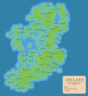
Ireland 2100.
The nightmare scenario.
Glug.
Kieran writes:
A mate and I made a worst case (70m rise) scenario sea-level rise map of Ireland for the year 2100. We imagined an Ireland after planned inland urban-sprawl as the sea-level will be relatively slow, with designated safe zones that government encouraged investment in.
We also imagined that most of Dublin’s wealth moved to Bray and Greystones forming the twin city of Braystones (which is slightly more inland than modern Bray and Greystones) while most of Dublin’s people moved to either Tallaght or Maynooth.
Cork/Ennis sprawled inland but most of it was lost, Derry completely relocated as the walled city was submerged and Gaway, Limerick and Waterford are all lost for the ages.
Each Island has a capital that represents the Island in government and each town has a representative in the island capital.
Not sure how to deal with the North as the islands didn’t really form along political borders and the towns became dependent on each other’s infrastructure. All in all, not super scientific or accurate but sure just a bit of fun…
G’wan the Braystones.
FIGHT!

The Archipelago formerly known as Ireland.
If Dublin’s going down I’m going down with it.
Happily Cork will be brought down too.
Braystones? NEVER! Sever the Dart lines and block the 184. Let not Greystones become Disgracestones.
I dunno.. sharp witted salt of the earth Bray folk rubbing shoulders with well behaved Protestant Greystones kids in a watery future….squabbling over boat taxis and how many deutsche marks the hover DART costs ….I smell a sitcom….
A world without the Northside. Count me out.
Luxury.
*phew*, i’ll be well dead by then.
Fupp you kids hahahahahah
i had my fun and that’s all that matters.
Mallow survives?!? Noooooooooooooooooooooooooooooo!!!
I reckon the map is wrong. I say that a lot of Cork is higher than they are showing.
Mt. Gabriel – 407m – why can’t I see it?
http://en.wikipedia.org/wiki/Mount_Gabriel
There are plenty other places higher than 70m, in West Cork and Kerry, that are not shown.
The high points were blown up in the Un-Cork’d Rebellion of 2084. Its a long stroy, but basically the rest of Ireland got fed up with Cork harping on about how great they are and bombed it though lazer warfare.
Things started going wrong when the local warlords chose Roy Keane as assistant warlord.
Looks like I’m alright.
Celbridge lives! I have a sinking feeling for the rest of ye.
I don’t think it does? Celbridge is south-east of Maynooth and it’s whole footprint looks a bit borderline on that dur map!
I’m kinda in between so fingers crossed wha?
Then we’re at cross-purposes, I wanna see Salesians go down ;)
I expect we might eventually get good at land reclamation and flood protection via a series of public-private initiatives, though the political corruption involved will make the land rezoning lottery look like a game of Monopoly.
A new job for John Tierney?
‘Moate’ …somehow the name seems more appropriate now.
Quick, Eamon Ryan Save us, you’re our only hope.
Rising almost 1 metre per year from today, relatively slow!!! WHAA?
relatively slow, horrifyingly fast on a geological scale but y’know
we could outrun it
Far be it for me to question these scienticians but how exactly does coastal Dingle survive where other towns go under the drink?
Lot of mountains around Dingle. Current Dingle would be underwater but I’d say it’s environs are what’s represented on this map.
costa del tallaght, eh? they’ll be swapping tracksuits for speedos. deckchair theft will be rampant – mark my words.
You’re not allowed in ;-)
scottser does not wear speedos – you should be glad for that.
That’s one big golf course
On the plus sign, more bridge-building and getting over themselves in the North.
GRAND MUNSTER – guess who’ll be only delighted?
I dunno… George Hook? He’ll probably be king, kept alive by some life-support powered by the energy within his many chins
Just to educate you lot further– Grand Munster is the name of the administrative centre for New Ireland which is based under Loch Gur in Limerick. We are well used to living in our wonder world under water already – so just show respect or we will give your name to Irish Water!!!!!!!!!!!!!!!!!!!
Galway & Limerick Gone!
Switches on Kettle, turns up heating, leaves car running for the weekend
Galway :(
You call a place with Mullingar, Cavan, Monaghan, Newry and Armagh on it “Leinster Straits”. How well do you think calling 4 parts of Ulster Leinster is going to go down?
“going to go down” he he
as an auld lad said to me recently:
“It’s all about elevation, elevation, elevation”
(as opposed to location location location)
Where’s the Castlecomer Plateau?
Most of Dublin’s people move to Tallaght or Maynooth? Honestly, I’d rather drown ;-)
You will
I was recently visited by a bald gentleman going by the name of Lex Luthor looking to buy beachfront property in Nenagh.
Now it all makes sense. (Puts cap back on marker)
Delightful waterland archipelago. Let’s make it happen!
100% dubious about that map. Did they just guess the elevations from. A lot more of Galway is above 70m then their map shows and Dublin too. That’s a fact.
Oh it can’t come quick enough – it would solve a lot of problems – sure Irish people cant live with each other!
This map is complete rubbish. Small villages on the coast don’t have any inland environs, they will be obliterated. Ballyvaughan being a prime example. The entire community will be gone, there are very few buildings above sea level in that area.
If you want an accurate flood map use: http://floodmap.net/ and set the flood level to 70m. It uses google maps so you can even see your own house.