


Tomboktu Cedarlounge writes:
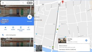
Have you noticed how Google Maps is assigning district names to Dublin’s streets? For example, it’s decided that Stirrup Lane is in “Inns Quay” (a designation taken up by a, ahem, most respectable website recently and that Green Street is in “Rotunda”. Inns Quay is nearly half a km from Stirrup Lane and the Rotunda is also 0.5 km away (as the crow flies) from the street designated as being in that “district”. Yeah, those districts are used for election nerds mapping voters but they’re not district names anybody else uses.
Sponsored Link
That too was botherin’ me yesterday.
The sub-divisions ABC explains why Stirrip Lane was ridiculously referred to as ‘Inns Quay’.
I don’t like this one bit. I thought it was just property developers that re-named entire sections of the city to sell gaffs (e.g. Heuston Quarter).
Ooooooo MMMMMMyyyyy
GGGGGGG!!??????????????????????? This is outrageous
Sure Roddy Doyle made a fortune telling everyone that the rich lived on the south side of Dublin and the poor on the north side. It ended up with gangs from Clontarf and Malahide marauding around Rialto and Inchicore stealing our women.
yeah those names are only used on other maps so what the hell are they using those names on maps for