

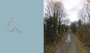

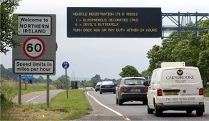
The Irish Border visualised street by street via Google Streetview
How the border looks on Google Streetview.
A fascinating ribbon of rural back roads offering hope, sanctuary and unlicensed diesel.
Keith writes:
A while back you posted an animation we made which visualised the Irish Border from above, well here’s something else I put together which tries to visualise the border on the ground using StreetView at the crossing points.
View the border here
Previously: Land Of Constant Sorrow
Sponsored Link


Quiz Time:
Do you think Mainland Brits are more surprised by the fact that:
A) Northern Ireland is already part of the United Kingdom
B) All of Ireland isn’t actually part of Britain at all
C) Ryayair isn’t British.
Vote now ……
Its the “Highway to Hell! Dinn, dinn.”
Wot, no tunnels ?
Ah, ha ha.
:)