‘sup?
Yesterday evening.
Unspecified location, County Kerry.
Thousands left without power as Storm Hannah crosses Ireland (RTÉ)
Thanks Sean Mac Gearailt and Slaine Ni Chathallain

‘sup?
Yesterday evening.
Unspecified location, County Kerry.
Thousands left without power as Storm Hannah crosses Ireland (RTÉ)
Thanks Sean Mac Gearailt and Slaine Ni Chathallain


Latest charts from ICON-EU just rolling out with Storm gusts from #StormHannah showing severe gusts with track a little further North than was showing yesterday. pic.twitter.com/STYCPKWtyR
— Carlow Weather (@CarlowWeather) April 26, 2019
Status RED – Wind Warning for Clare
Northwesterly winds, associated with Storm Hannah, will reach mean speeds in excess of 80 km/h with violent gusts of 130 to 150 km/h for a time this evening.Valid from 20:00 hours Fri, 26-Apr-2019 until 23:00 hours Fri, 26-Apr-2019 pic.twitter.com/in33m0y5my
— Met Éireann (@MetEireann) April 26, 2019
Met Eireann has announced that there is now Status Red wind warning (gusts of up to 150kph) out for Clare from 8pm until 11pm tonight, on account of Storm Hannah.
It’s also announced that similar gusts may reach Connemara, the Aran Islands, Dingle and the coasts of Kerry, Cork and Waterford.
Carlow Weather will be live tweeting updates from 5pm here
Earlier: Thar She Blows
Pic: Carlow Weather
UPDATE:
Status Red for Kerry now also:
Status Red – Wind warning for Kerry
Northwesterly winds, associated with Storm Hannah, will reach mean speeds in excess of 80km/h with violent gusts of 130 to 150 km/h in places this evening between 6pm and 8pm.
Valid: Friday 26 18:00 to 20:00 pic.twitter.com/Uyd1bVT9pk
— Carlow Weather (@CarlowWeather) April 26, 2019
UPDATE:
#StormHannah Wave height increasing at Buoy K2 150Km south west of the Kerry coast. Wave heights of 32 feet or 9.6m and rising. pic.twitter.com/ZGxGP3BXKW
— floodingireland (@floodingireland) April 26, 2019

Carlow Weather tweetz:
The outer bands of #StormHannah are approaching the Southwest coast with heavy rain showing on the Radar and the system is looking very well defined on Satellite image now. Winds will increase later this afternoon to severe gusts.
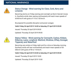
Met Eireann have issued several weather warnings:
A Status Orange wind alert (gusts of up to 130kph) for Clare, Cork, Kerry and Limerick which will be valid from 4pm today to 1am tomorrow.
A Status Orange wind warning for Galway from 7pm this evening to midnight.
A Status Orange wind warning for Tipperary and Waterford from 10pm tonight to 2am tomorrow.
A Status Yellow wind warning (gusts of up to 110kph) for Connacht, Carlow, Kildare, Kilkenny, Laois, Longford, Wexford, Wicklow, Offaly, Donegal, Tipperary and Waterford from 11pm tonight until 9am.

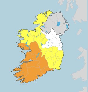
From top: Showers in Carlow; satellite image of Ireland; Met Eireann’s weather warnings
Carlow Weather tweetz:
Weather warnings issued now by Met Eireann for #StormHannah includes Status Orange – Wind warning for Clare, Cork, Kerry and Limerick and Yellow for many other areas.
*Squelch.*