
This afternoon.
Carlow Weather tweetz:
“Plane surveying or what do you think it is doing?”
Yikes.
Meanwhile…
Screenshot of the other day too… pic.twitter.com/Qw6XK0YWUR
— Donal McAlister (@Donalmca) April 15, 2020
Anyone?

This afternoon.
Carlow Weather tweetz:
“Plane surveying or what do you think it is doing?”
Yikes.
Meanwhile…
Screenshot of the other day too… pic.twitter.com/Qw6XK0YWUR
— Donal McAlister (@Donalmca) April 15, 2020
Anyone?
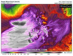

Latest ICON-EU charts for Wind gusts on Saturday and Sunday. #StormCiara pic.twitter.com/UHxLQLVdYc
— Carlow Weather (@CarlowWeather) February 5, 2020
Met Éireann writes:
“Current indications suggest a very strong to near gale force and gusty southwest wind will develop on Sunday along with heavy rain, as Storm Ciara tracks to the north of the country.
“The rain will clear to showers and squally westerly winds later in the day and some of the showers possibly of hail and thunder. Highest temperatures 10 to 13 degrees. Cold overnight with lows 0 to 3 degrees.”
Yikes.

Carlow Weather tweetz:
Fair play to ESB Networks. Power has been restored to my weather station near Tullow [Co Carlow], top gust at my station was 99.8kmh. Webcam looking east showing nice afternoon after Storm Brendan.
UPDATE:
Correction, looking at data from my station which has battery backup, the top gust was 105.6kmh at my station. pic.twitter.com/ttZgD6D4QV
— Carlow Weather (@CarlowWeather) January 13, 2020
Earlier: The Brendan Voyage
UPDATE:
Flooding on the promenade in Salthill as high tide hits #stormbrendan More on @VirginMediaNews at 8 pic.twitter.com/qx9TseJ3BW
— Paul Quinn (@PaulQuinnNews) January 13, 2020
High tide here in Salthill where the water is overtopping the flood defences pic.twitter.com/WUwPiCbsCT
— Shane Beatty (@ShaneBeattyNews) January 13, 2020
UPDATE:
Here’s an epic slow motion sequence of Thunder Child II hit by a couple of massive waves during Storm Brendan today, beautifully shows the power and majesty of the sea. #StormBrendan @captainbob76 @MaryP972 A nice video follows @LarryCpix @mbymagazine @urlofcork @AfloatMagazine pic.twitter.com/tYZwIU0QVc
— Safehaven Marine (@SafehavenMarine) January 13, 2020

Table which includes predicted times of sunrise and sunset over the next month
Carlow Weather tweetz:
“Doesn’t it feel like the darkest morning ever? Dark clouds preventing any moon light makes it a dark morning but the good news is the stretch continues.
“Sunrise of 08:38 this morning but it will be 08:13 by end of month and sunset today at 16:28 will be 17:09 at end of month.
Finally.

Carlow Weather tweetz:
A lovely break in weather today with lots of pleasant winter sunshine. Make the most of it as the next round of wet and very windy weather is already lining up out in the Atlantic and will arrive tonight with an awful day ahead tomorrow. Turning much colder tomorrow evening too.
Sigh.
Meanwhile…


Met Éireann has released a “weather advisory” for Ireland tomorrow, from 4am until 4pm. To wit:
Tuesday will be a blustery day with strong winds and very gusty conditions associated with an active front moving eastwards across the country. Generally, winds will be below warning thresholds but damage to some structures and trees, already weakened from the effects of Storm Atiyah, is possible.
Rain and showers will be heavy at times as well, especially in Atlantic coastal counties.
Meanwhile…
In Cork at the weekend…
The trampoline that made it’s way onto the road in Turners Cross. #StormAtiyah pic.twitter.com/YPwIjRwBa2
— Cork Safety Alerts (@CorkSafetyAlert) December 8, 2019
Images: Carlow Weather


Oh.
Carlow Weather tweetz:
The Jet stream visible on the air-mass satellite view, this is powering up the low system which is developing out in the Atlantic and will bring heavy rain tonight and tomorrow along with strong winds off South coast.
Meanwhile…

Met Éireann has issued a Status Yellow rainfall warning for Clare, Cork, Kerry and Limerick with the warning remaining in place until midnight tomorrow night.
It’s also issued a Status Yellow wind warning for Wexford, Cork, Kerry and Waterford with the warning remaining in place until 6am on Saturday.


This morning.
Carlow Weather tweetz:
What a stunning start to the day with an amazing sunrise here in Wexford. A nice day ahead, staying dry with the odd sunny spell after a low of -0.6c at my station.

Latest GFS charts rolling out show #Lorenzo taking a quicker turn East over Ireland with severe gusts on West coast. Just one possible outcome though as it is far from clear yet where exactly it will end up. More updates later. pic.twitter.com/ppbs5ruToz
— Carlow Weather (@CarlowWeather) October 1, 2019

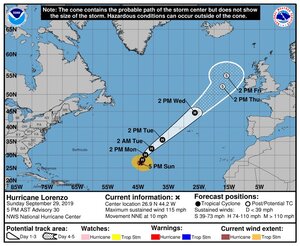
Carlow Weather tweetz:
“Latest [Hurricane Lorenzo] update: The National Hurricane Center track forecast has been adjusted a little to the left to come into better agreement with the latest consensus aids. Although the spread in the models is not as large as it was yesterday, the forecast beyond 48 hours is still of low confidence.”
Met Éireann ‘closely monitoring’ Hurricane Lorenzo (RTE)
Top pic: National Hurricane Center
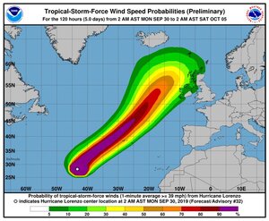
UPDATE:
Latest GFS weather charts just rolling out and it takes #Lorenzo back in over Ireland just like the last update. This is going to be very difficult to forecast. Keep up to date with forecasts. I’ll have more details later as more information becomes available. pic.twitter.com/rNpF6c8OWY
— Carlow Weather (@CarlowWeather) September 30, 2019

Carlow Weather Guy tweetz:
This photo sums up the [National Ploughing Championships] @NPAIE #Ploughing19
Beautiful lines (if sloppy ‘ripple’), In fairness.
Not like last year then.