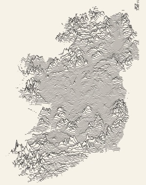
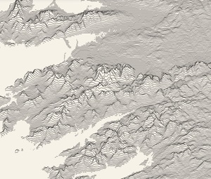
Create a ridgeline map of any terrain on Earth (in the style of Joy Division’s ‘Unknown Pleasures’ album cover) with Andrei Kashcha’s Peak Map tool.
Explore it here.

Create a ridgeline map of any terrain on Earth (in the style of Joy Division’s ‘Unknown Pleasures’ album cover) with Andrei Kashcha’s Peak Map tool.
Explore it here.


Aerial Project ‘33K’, of which creator, Pulitzer prize winning photographer Vincent LaForet sez:
Over several months of prep and R&D we modified a LearJet and flew above the earth looking straight down at the shear beauty of what Mother Nature has to offer us that we all too often miss from the ground. Shot on RED in 8K.
Previously: The London Look


Every month, the Mars Reconnaissance Orbiter (MRO), launched in 2005, sends images back to Earth.
A recent batch of more than 1,000 photographs coincided with the Martian equinox when the sun shone directly onto the planet’s equator, revealing clear views of a surprisingly diverse, multicoloured terrain normally shrouded in darkness.
View the complete image set here.


Argentine artist Alexandra Kehayoglou’s lush hand-tufted carpets and rugs which resemble al manner of watery, pastoral, tussocky goodness.

Of this recent image taken by the Mars Reconnaissance Orbiter, NASA sez:
Mars’ seasonal cap of carbon dioxide ice has eroded many beautiful terrains as it sublimates (goes directly from ice to vapor) every spring. In the region where the High Resolution Imaging Science Experiment (HiRISE) camera on NASA’s Mars Reconnaissance Orbiter took this image, we see troughs that form a starburst pattern. In other areas these radial troughs have been refered to as spiders, simply because of their shape. In this region the pattern looks more dendritic as channels branch out numerous times as they get further from the center.
The troughs are believed to be formed by gas flowing beneath the seasonal ice to openings where the gas escapes, carrying along dust from the surface below. The dust falls to the surface of the ice in fan-shaped deposits.