



Tag Archives: map


Timmy writes:
I made a little web app that might interest your readers now that temperatures are dropping and Christmas festivities are beginning: It’s a map of (currently dublin-centric) pubs that have a nice warm fire inside. I’m looking for more pubs to add and can be contacted via Twitter.

Nobody wants a Raleigh anymore.
They want your Giant Defying Treks.
Dublin Cycling writes:
Bike theft is a big and growing problem in Dublin. While only 4,500 bikes were reported stolen in Dublin in 2013 we know there is a big under-reporting problem and we estimate that the real figure was around 20,000. The information you will provide in this survey [link below] will be invaluable in helping us design a plan, in conjunction with the Gardai, City Council, City Planners& Bike trade, to tackle the problem

They missed a bit.
Daniel Keogh writes:
“An interesting world map in the Great Wall Museum at Badaling, outside Beijing….”


Eurozones
at
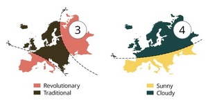


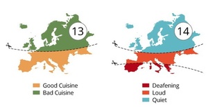


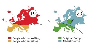

Europe – satirically carved-up in 20 stereotypical and prejudicial ways by author and cartographer Yanko Tsvetkov.
Taken from his book Atlas of Prejudice 2: Chasing Horizons (Volume 2).


Created by digital artist Eowyn ‘theantilove’ Smith: a map of the geographical locations of 44 Disney and 13 Pixar films from Snow White and The Seven Dwarfs (1937) to Frozen (2013).
Full image and key here.
Unmappable films like Wall-E and Monsters Inc appear in an inset. Elsewhere, following furious pedantry on Reddit and DeviantArt, Smith clarifies:
1. Movie was placed based on the location IMPLIED IN THE DISNEY/PIXAR VERSION
2. If the movie was too vague to determine a location, the original story/myth was consulted.


In 2010, world traveller Bill Passman had a blank map of the world tattooed on his back with a view to colouring in the countries he’d already visited [pic2] (and all those he’s visited since [pic3]).
He visited Ireland (and Norway) in the Summer of 2007.
Passman is currently working his was through India, Burma, Thailand, Vietnam, and Indonesia.
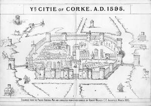
A map of Cork circa 1595 from the booklet ‘The City of Cork: how it may be improved’ by Robert Walker (1883).
Not one but two shaky bridges.

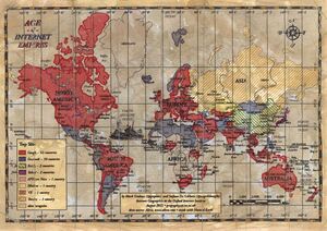
“Two researchers, [former Trinity College lecturer] Mark Graham and Stefano De Stabbata, at the Oxford Internet Institute, have depicted the world’s “Internet empires” in a map, above. The map shows each nation’s most popular website, with the size of nations altered to reflect the number of Internet users there.”
“The map makes for a brief, informative look at how geographic—and universal—certain web tastes and habits are.”
They also created this old timey map-style, below:
Gnarly.
Previously: Twitter Hate In The USA
Age of Internet Empires: One Map With Each Country’s Favorite Website (The Atlantic)